
Annonse
Outdoor life Norway
Jutulhogget
- the unique and magnificent canyon
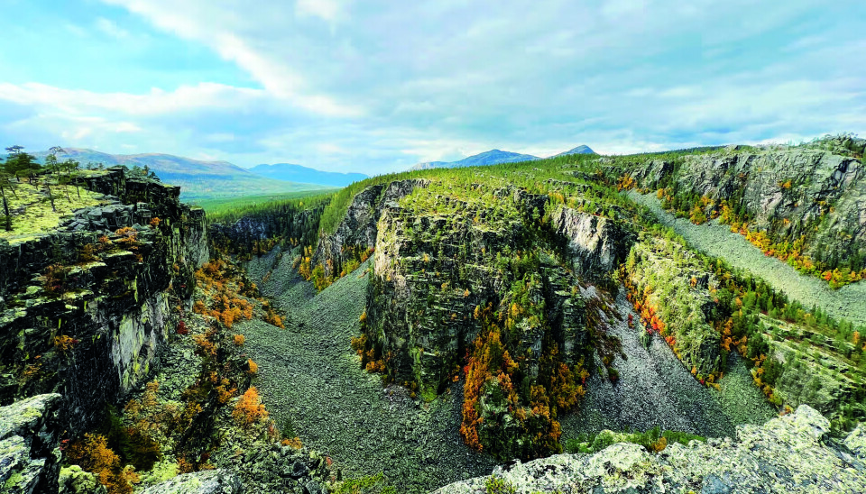
A hike along the steep edge of the entire Jutulhogget can be summarized as follows: Terrifying, scary, creepy, gut-wrenching, slightly dizzy, and trembling knees. And at the same time - a close encounter with a fascinating natural phenomenon!
Published
Modified
Annonse
It is extremely steep. The mountain wall in the gorge descends sharply to the enormous pile of rocks at the bottom. One thing is to stand behind the safety fence and look out towards a part of the canyon. Another thing is to walk the 2.5 km along the edge of the entire Jutulhogget. And then, of course, it is about walking as close to the edge as possible so that you can look down into the gorge along the way.
Jutulhogget is located just south of Alvdal. It is only a few hundred meters from RV3 up to the parking lot at Jutulhogget. At the parking lot, there is a map with information, and the path to the viewpoint is not long either. There are a series of safety fences along the western end of the gorge. There is also a shelter there with information posters about Jutulhogget.
Link to map

Along the edge
We took the trip along the south side of the gorge. There is no marked trail, but a quite clear path in the terrain. After about a kilometer, the path becomes less and less visible. It is clear that most sightseers stop at the safety fence on the west side and snap pictures, while some take the hike a bit further along the edge on the south side. After halfway and towards the eastern end of the gorge, there is little human trace.
The terrain along the edge is somewhat challenging. It consists of partially hilly landscapes with reindeer lichen, sharp stones, pine trees, heather, grass, wet marshes, and large rock surfaces. In some places, there are small ponds and puddles that one must walk around.
Midway through Jutulhogget (about 620 meters above sea level), there is a ridge with a very good view of almost the entire gorge. From here, you can look across to the steep west side and out towards the gentler end of Jutulhogget in the east. The journey eastward is correspondingly easy downhill as one ascended to the middle part of the canyon.
Annonse
At the bottom
It is possible to go down to the bottom of Jutulhogget. There is a small path down into the gorge about 100 meters north of where the shelter stands. This is not a path for everyone. It is very steep down, and there are only some trees, bushes, and stones to hold onto. At the bottom, there are only sharp, large stones. It is not easy to walk on this surface. It is not recommended to go down into the gorge when it has rained and is wet and slippery. At the bottom, the view up towards the steep edges is impressive. Fortunately, it is easier to go up again than it is to go down.

The Ice is Melting
Norway has been covered by large glaciers several times during the last two to three million years. The last ice age began about 115,000 years ago. The climate has been constantly changing since then. The glaciers that covered the country have grown and shrunk. The inland ice had its greatest extent about 20,000 years ago. At that time, it was probably only the highest mountain peaks that protruded above the ice.
When the last ice age ended just 10,000 years ago, the ice first melted along the coast. It quickly became much warmer, and the large inland ice and
all the glacier arms began to melt. Gradually, the ice edge moved inland, and in just over a thousand years, only a small part of the inland ice remained. In the inner parts of Eastern Norway up towards Røros, the areas in the north became ice-free first. Further south, there was still ice. The remnants in the south acted as a dam against the water masses, and dammed lakes were formed. These had their outlets towards the north. The rivers Gaula and Driva thus drained the water from these lakes.
Annonse
Several Lakes
As the inland ice melted, it dammed up several lakes in the northern regions of Eastern Norway. Traces of ancient lakes have been found both in Gudbrandsdalen and Østerdalen. Similar lakes have also been mapped in the mountainous areas northward in Sweden. Thus, ice-dammed lakes were not uncommon at the end of the ice age. Today, we must go to Greenland to find such lakes.
The size and extent of the lakes can be inferred because they have left many traces in the terrain. The lake was thus larger than Mjøsa and Femunden are today. The most common trace is so-called shoreline lines. They are also called 'seter' due to their shape. In local language, they are known as 'såttå'. As the name suggests, the 'seter' are fairly narrow terraces formed by wave action in the loose moraine gravel that the ice had already deposited in the valley sides.
The Dam Breaks
The inland ice melted and disappeared quickly in the relatively warm weather after the ice age. Water ran everywhere; over the ice, under the ice, inside the ice, and it all ended up in the large rivers in the valley bottoms. The dam in Rendalen must have become increasingly weaker as the ice melted. Here the pressure was also extra great because the valley bottom in Rendalen lies 200 meters lower than in Østerdalen.
Suddenly, the dam burst. The great catastrophe was a fact. The enormous masses of water flowed with tremendous force out of the lake and down Rendalen. Ice blocks, stone, and water must have been a terrible chaos, and a deafening noise could have scared any troll. Colossal whirlpools occurred in the lake itself.

Jutulhogget Formed
Barkaldkjølen is the lowest point between Østerdalen and Rendalen. Here it was relatively shallow, and the water being sucked past created violent whirlpools. It is easier to understand what happened if we compare it to what happens when the plug is pulled from the bathtub. The whirlpools tore away huge stone blocks from the brittle and cracked rock, threw them down towards Rendalen, and crushed and ground them up in an inferno of water and stone. Everything happened at a tremendous pace. The water level dropped quickly, and a long, thin crack in the rock became visible. Jutulhogget was formed.
The water level had dropped a full 155 meters within a few days. It is no wonder that the forces of nature have left their mark.
This article was published in Friluftsliv issue 5/2022